|
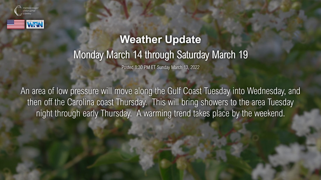
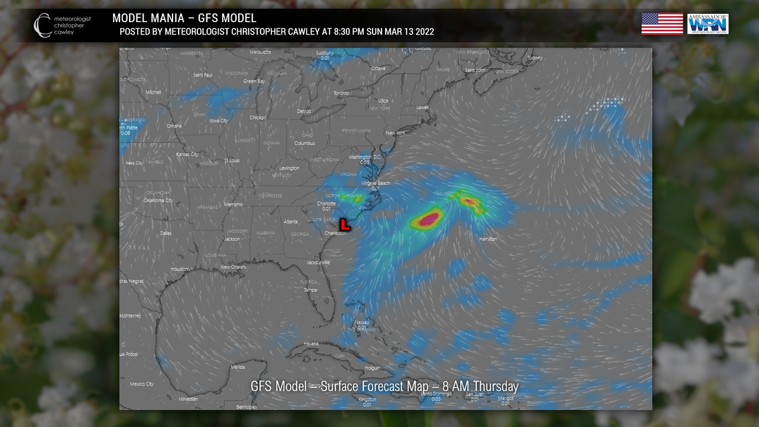
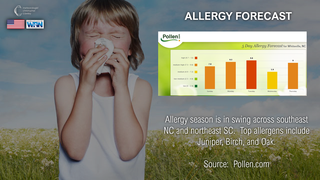
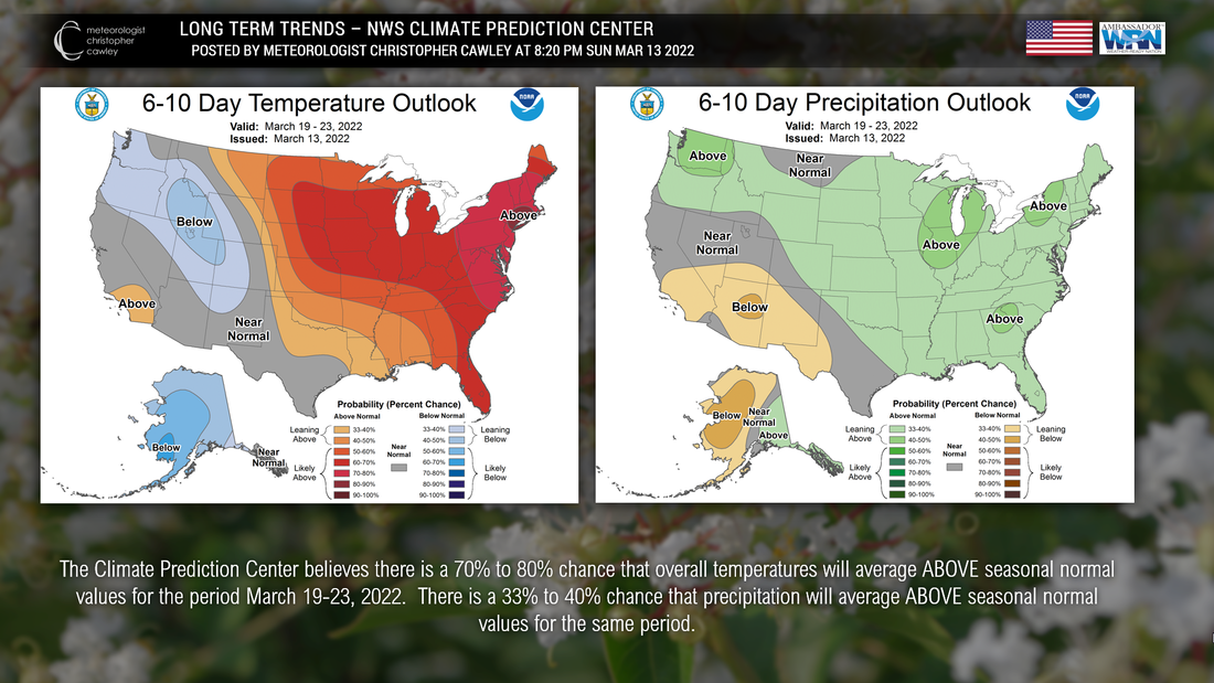
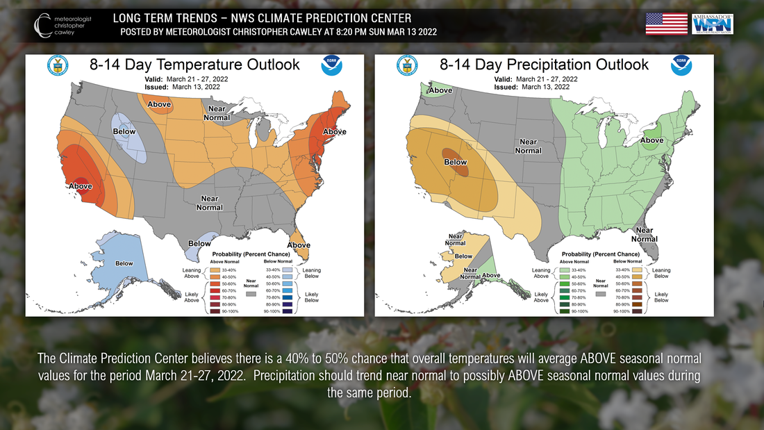
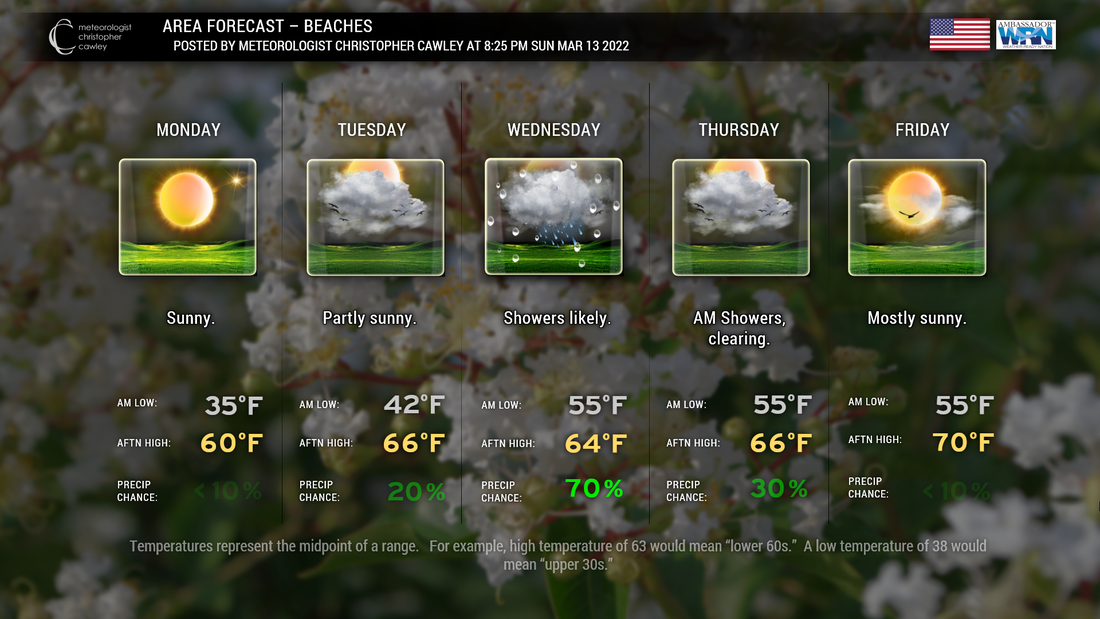
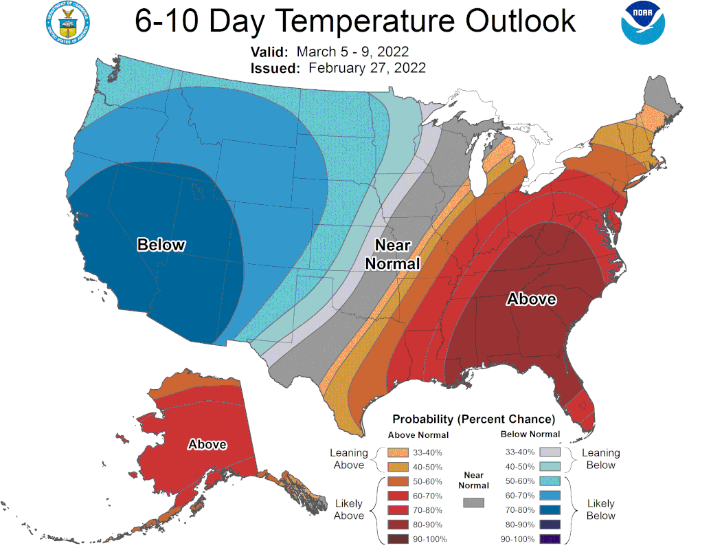
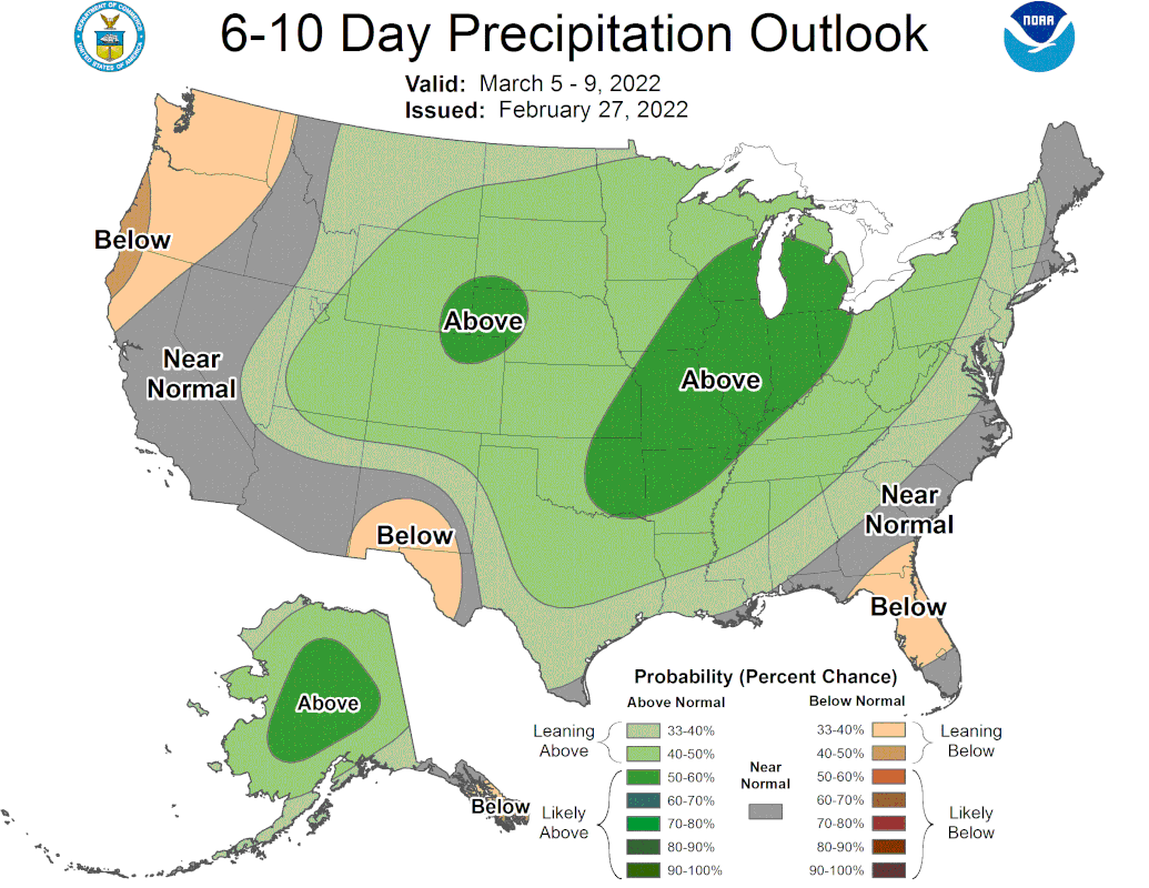
Hello and welcome to the return of the weekly blog. This is the weather summary for Monday March 14-Saturday March 19, 2022, for southeast NC and northeast SC. Our weather will be quiet Monday and Tuesday. Low pressure moving through the southeast will bring the threat for showers Tuesday night into early Thursday, followed by dry weather and warming temperatures. (Click/tap on the image to enlarge.) Old man winter is making one last stand with sub-freezing temperatures Sunday night/early Monday morning. After that, there is no indication whatsoever that we'll have temperatures below 40°F through the end of the month of March. A wave of low pressure is expected to become organized Tuesday along the Gulf Coast. This will move to a position over northern Florida by Wednesday, and then off the Carolina coast early Thursday. I expect rain showers to develop late Tuesday afternoon or Tuesday night. Wednesday looks wet with scattered to numerous showers... coming to an end Wednesday night or early Thursday. Both the GFS and European modeling shows some showers lingering early Thursday morning. Click on the images to enlarge. Storm total rainfall from this event, as of now, should be less than one inch... but Wednesday will be a fairly rainy day. After that, I expect dry conditions Thursday and Friday, but clouds will be on the increase Friday ahead of the next frontal system, which may bring shower chances next weekend. Temperatures will warm well into the 70s ahead of this next frontal system. ALLERGY SEASON has arrived!!! Our pollen counts are going to run on the medium-high side through the week, tempered a bit on Wednesday thanks to clouds and rain. The primary allergens include Juniper, Birch, and Oak, per Pollen.com. Looking ahead, I mentioned that the sub-freezing temps appear to be winter's last stand. The Climate Prediction Center has a strong belief that much of the eastern half of the country is going to see above-normal temperatures through the end of the month. Precipitation should average out near to slightly above normal. Click on the images to enlarge. MY FORECASTS: Monday will be a bright sunny day across SE NC and NE SC. After a frosty start, highs will be in the lower to middle 60s, a bit cooler right at the beaches. Monday night should be clear with lows a few degrees either side of 40 inland, lower to middle 40s at the water's edge. For Tuesday expect clouds to be increasing throughout the day. Temperatures will be a bit milder, near 70 inland with mid 60s at the beaches. Expect shower chances to increase Tuesday night with lows in the mid 50s. Showers are likely area-wide on Wednesday with highs generally in the mid to upper 60s. Those shower chances come to an end Thursday morning with clearing skies, and Friday should be partly sunny with highs around 70 at the beaches... into the mid 70s inland. Okay that'll do it for tonight, I hope you find this information useful, and if you do, feel free to share! Thank you for taking the time to read through this blog and let me know if there any ways I could improve this!
-Chris
0 Comments
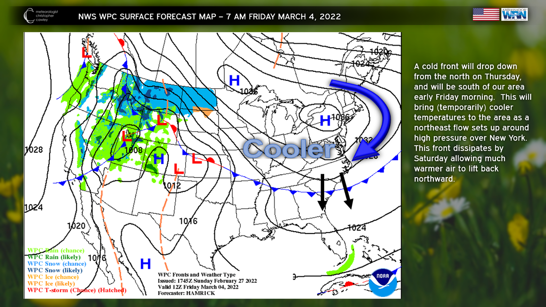
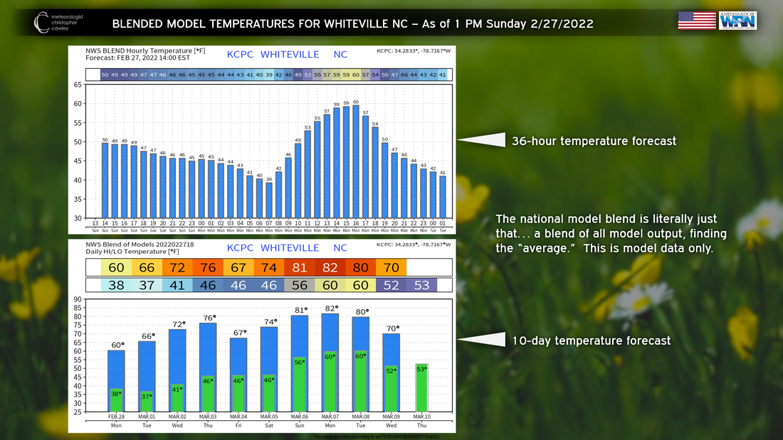
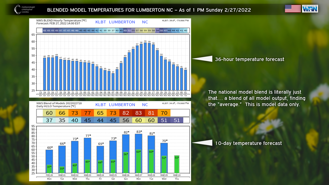
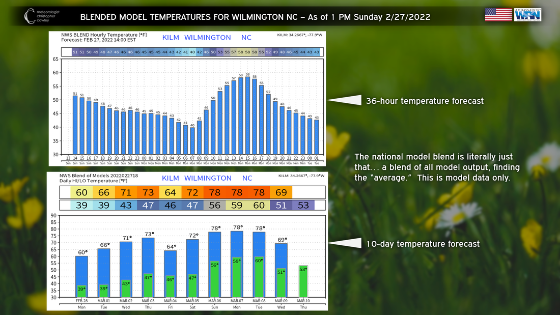
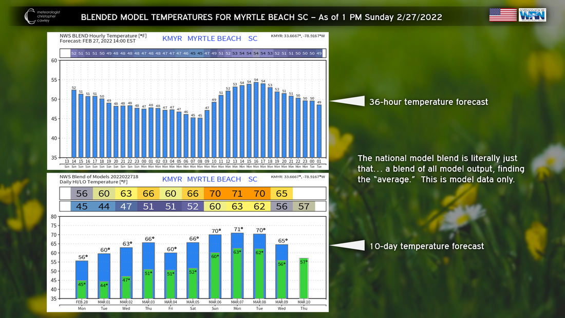
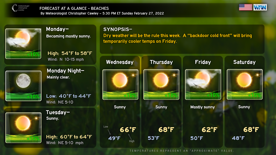
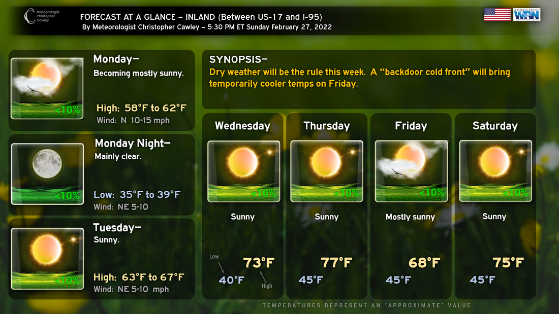
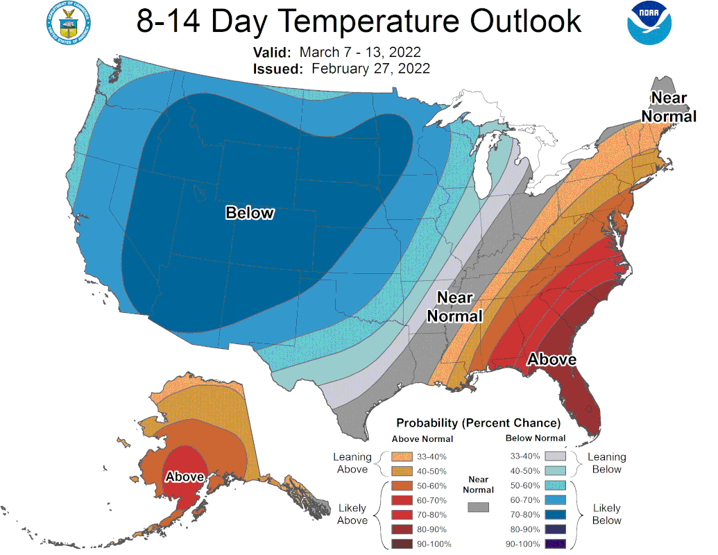
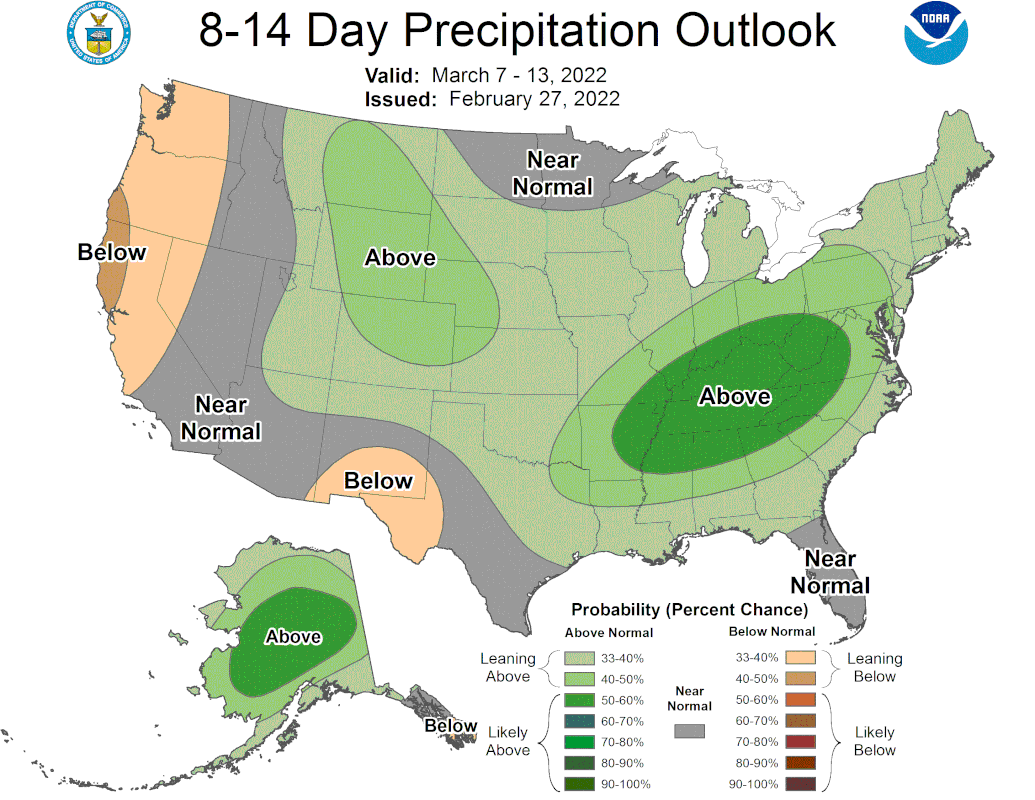
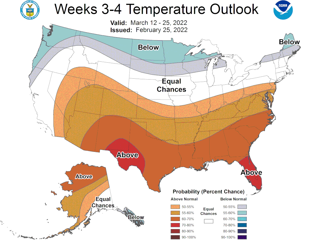
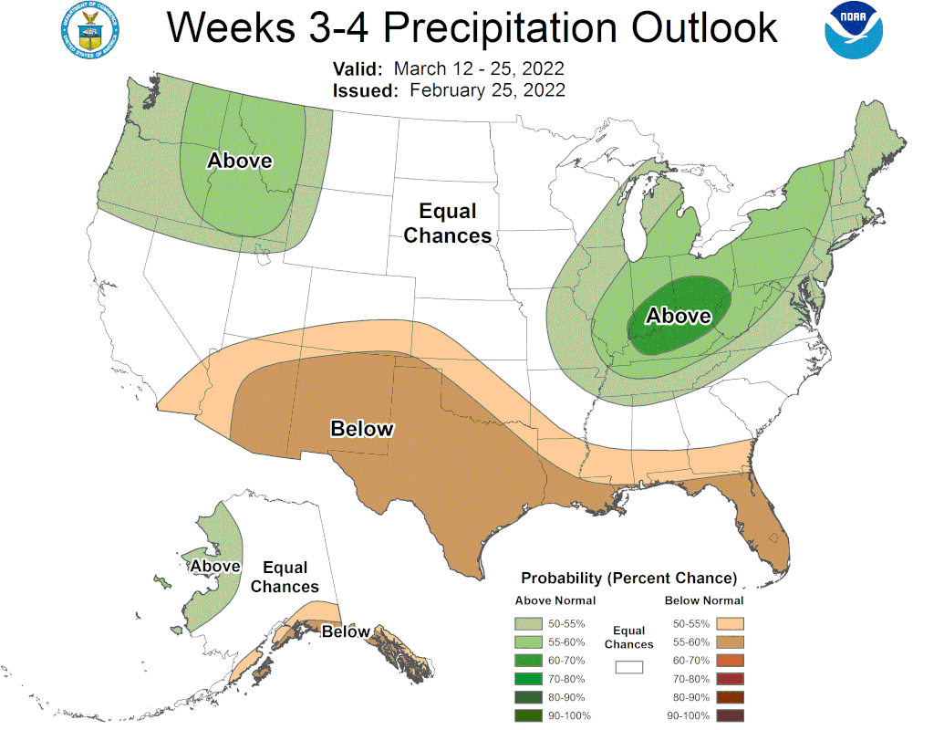
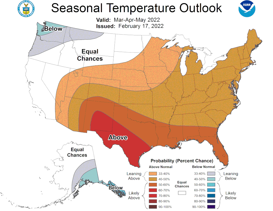
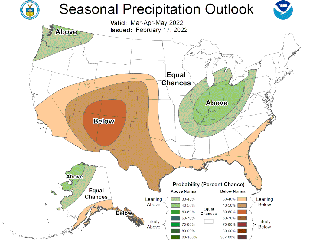
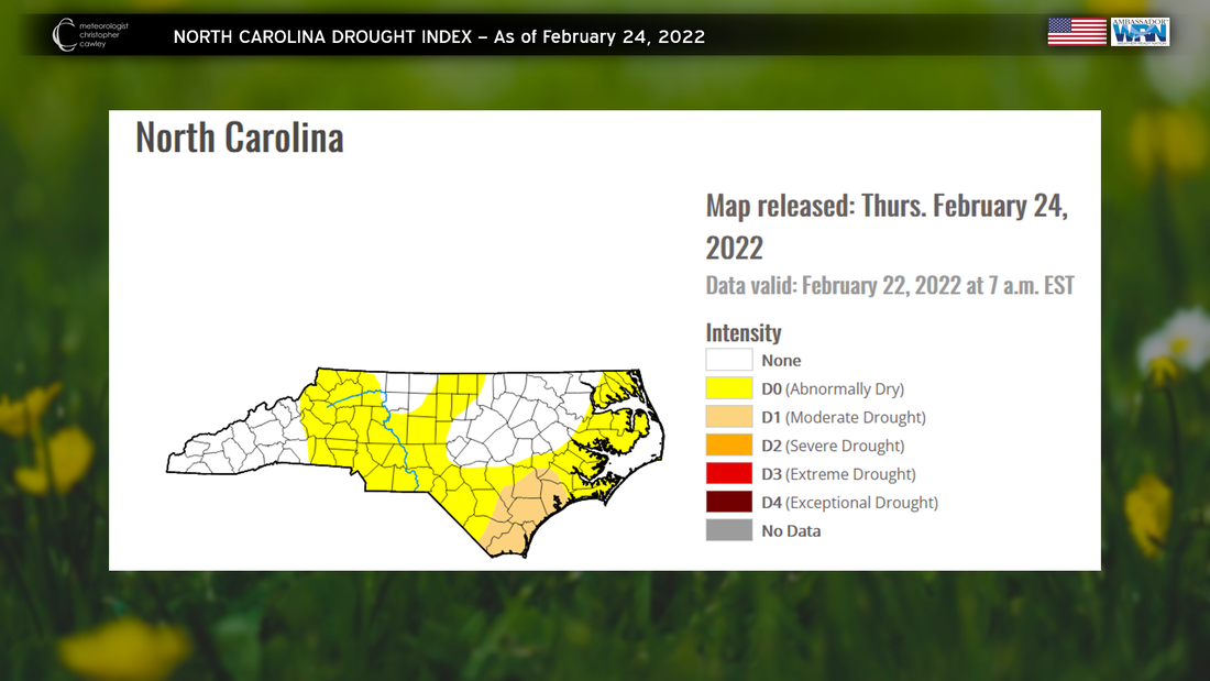
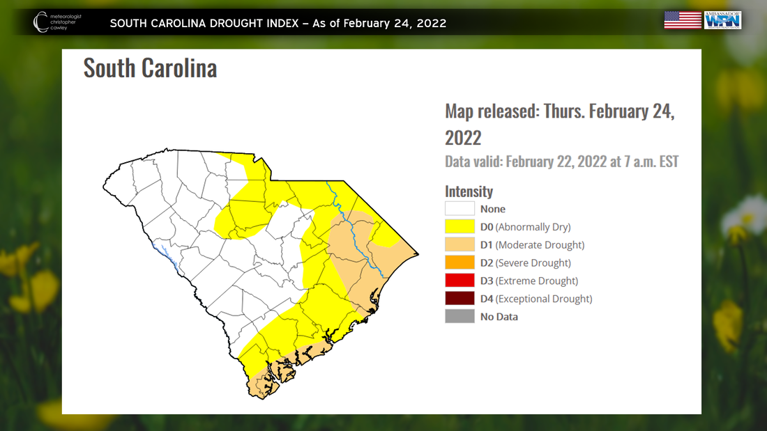
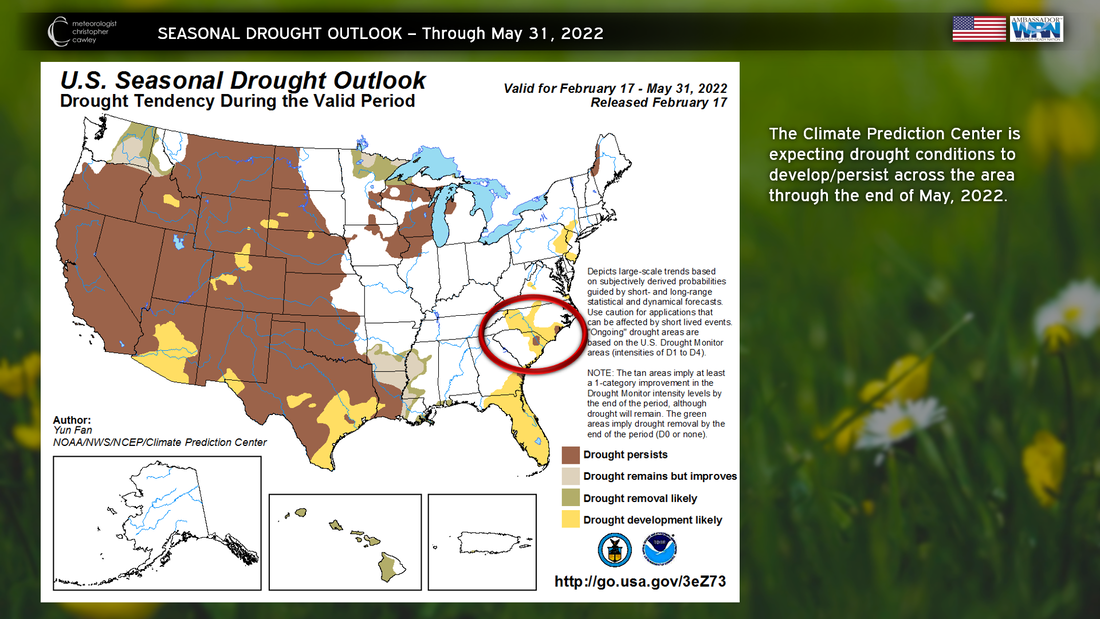
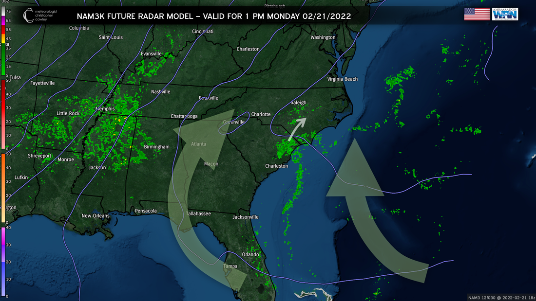
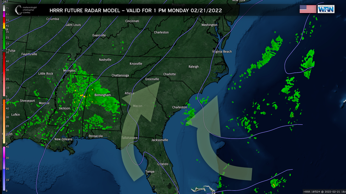
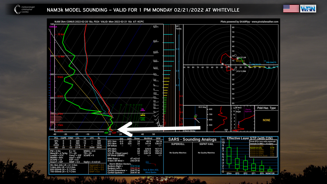
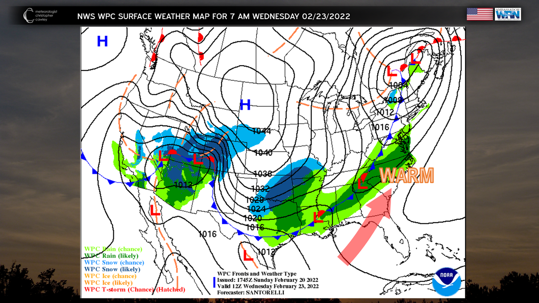
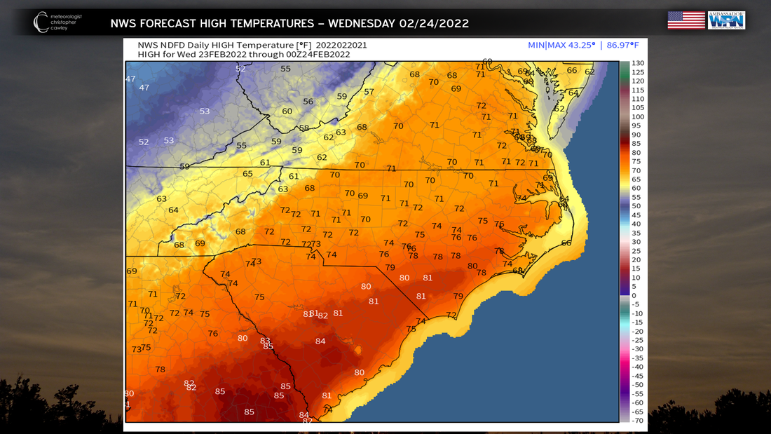
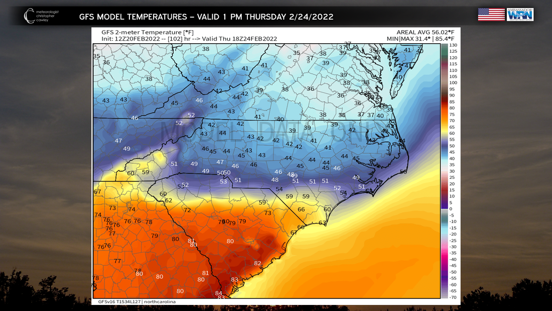
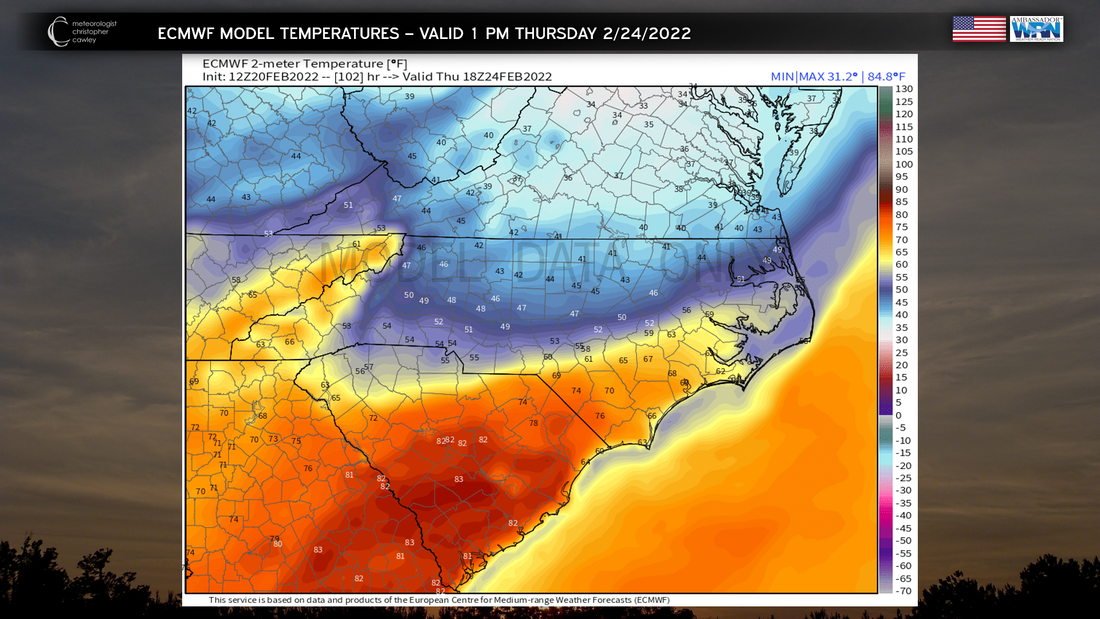
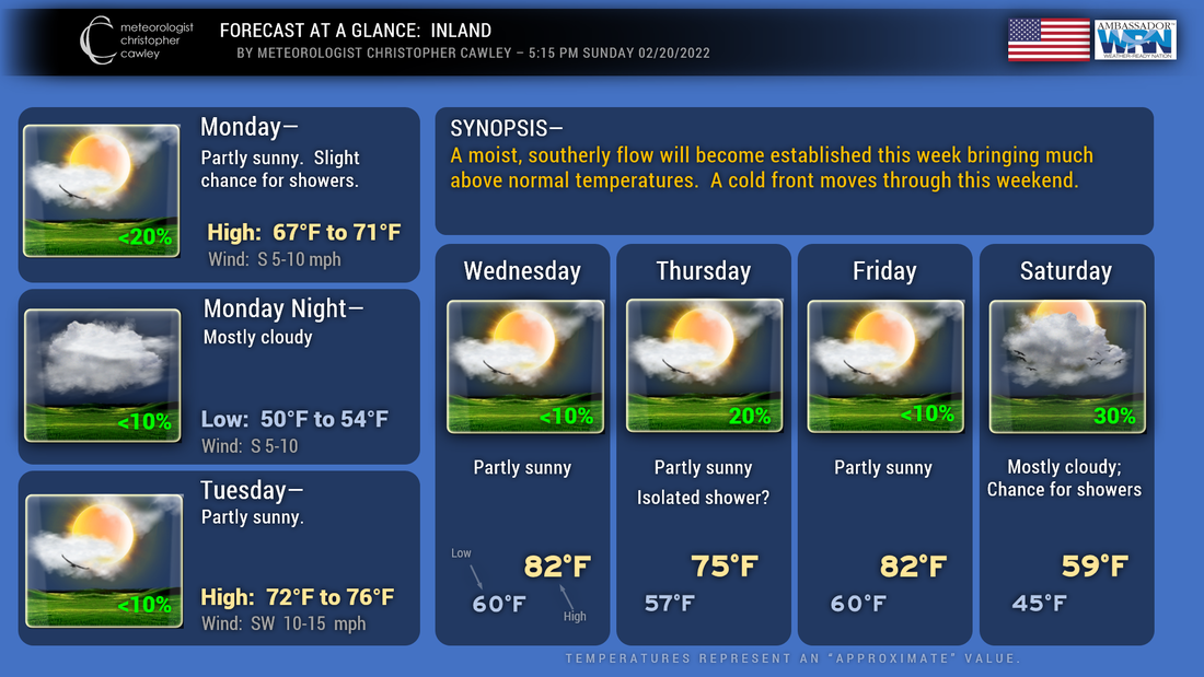
(Click/tap on images to enlarge.) Today's blog just doesn't have a lot to talk about! Our weather system that brought the rain to our area today is exiting stage-right as I write this. All models show near-zero precipitation chances through the work week. Temperatures will show a definite warming trend... but that warming trend will be stopped (temporarily) on Friday as a "backdoor cold front" drops south over the area. The above map shows the cold front south of our area early Friday morning. A northeasterly wind flow will bring cooler temps to the area (actually, temps will return to where they should be the first week in March). The following slides show expected temperatures over the next 36 hours and then for the coming week. This is as of model data posted at 1 PM Sunday. I don't see any reason to "hate on" these numbers and believe they're going to be pretty accurate. Again, click on each image to enlarge. Here are my forecasts for beaches and inland areas. Taking a look at more long-term trends, it really does appear that spring has sprung across the Carolinas. The Climate Prediction Center's latest forecasts show a near-certainty for above-normal temperatures through March 13th, with near-normal to slightly above normal precipitation chances over the same time frame. Extending beyond that, the CPC expects a 60% to 70% chance of our area experiencing above-normal temperatures through March 25, with near-normal precipitation chances. Going even farther, the latest seasonal outlook (March, April, and May) calls for a 40% to 50% chance of above-normal temps with near-normal to slightly below normal precip chances. It should be noted that these are "broad" forecasts -- there may be periods where temps run below normal or we get periods of rain. Finally, let's take a look at the latest drought information. Yes... the coastal Carolinas are in a drought, and the long-term outlook through May 31, 2022, calls for a continuation/development of this drought. Again, that doesn't mean we won't get any rainy periods, but "on the whole," dry conditions are expected to persist. Ok, that'll do it for this update. Again, there simply isn't a lot to talk about for the weather this coming week. Enjoy the sunshine and the warming temperatures. I expect allergy season to have an early start... azaleas are already starting to bloom. I imagine grass and tree pollen will start to fly as warm temperatures dominate the next 2 weeks. I hope everyone has a great and safe week. Thank you for taking time to read this blog, and feel free to share! -Chris I'm going to try this in a "blog" format since FB wants to slap a "climate change" tag to all of my posts. My posts aren't political and I'm just not going to have it. Anyway, we have a BIG TIME taste of spring coming this week. A frontal system will wreak havoc in temperature forecasting later in the week, followed by another push of very warm temps... before a cold front brings us back to reality by next weekend. For Monday, a southerly flow of winds will set up as high pressure lifts off the east coast. This will allow for our temps to climb to near 70 inland... with temps staying in the mid 60s along the coast thanks to colder ocean water temps. The latest NAM3k model shows an area of showers (mainly light showers) lifting north throughout the day Monday. If this model is to be believed, light showers will impact areas primarily east of I-95 from south to north during the day on Monday. This is the NAM3k future radar model for 1 PM Monday. The big arrows indicate the general flow of wind and moisture. The white arrow shows the movement of the expected precipitation (click on the graphic to enlarge). The HRRR modeling does not show this feature, other than a hint of some showers just offshore. I believe whatever precipitation occurs will be light and spotty. The precipitation would be caused by something known in meteorology circles as "isentropic lift." This is a "lifting" of air causing lots of cloudiness and precipitation. In some cases it can cause widespread rain and even convective elements (thunderstorms), but this won't be the case today. The lift is very shallow, trapped beneath a fairly robust "inversion" (where temperature rises with height instead of falling). The warm and humid southwest flow will continue on Tuesday as a fairly strong area of low pressure lifts northward from Missouri into the Great Lakes. I expect partly sunny skies (probably a 50/50 mix of sun and clouds) with temperatures well into the 70s... even around 70 to the beaches. The colder ocean waters won't have as much impact given the southwesterly wind component. Southern Brunswick county beaches may still see highs stuck in the upper 60s. We REALLY warm up on Wednesday. The aforementioned area of low pressure will push a frontal boundary in our direction, and the southwesterly wind flow will ramp up. The map shows a few ripples of low pressure on that front, helping to enhance our warm temperatures. How warm? How about highs punching into the 80s. The NWS is calling for highs into the 80s for much of southeast NC away from the coast (temps in the lower to middle 70s along the coast). After Wednesday the forecast becomes quite challenging. The low(s) forming on the cold front will "kink" the front a bit... it will stop the front's southward progression through North Carolina. The modeling shows a fairly dramatic difference in temperatures north of the front vs south of the front. The GFS model, as shown below, brings the front the farthest south, extending west-to-east across extreme northern South Carolina, to a line from roughly Bennettsville through Lumberton, Elizabethtown, to Burgaw. The European model (below) keeps the front farther to the north (with a bit of a wedge feature across western NC)... warmer temperatures extending farther to the north. Regardless of the position of the front, I don't expect much (if any) precipitation locally on Thursday. On Friday, the low that causes the kink in the front moves north off of the coast of Long Island, while a second low forms over northeast Pennsylvania. A nice little snowstorm sets up for New York and New England, while our temps SOAR into the 80s once again. The cold front (for real this time) finally moves west to east across the state Friday night into Saturday bringing showers... and an end to the springlike temps. Model total precipitation for the entire week is meager. While I think we're going to see lots of clouds over the week, I don't think we'll see a lot of rain. The precipitation on Thursday should remain NORTH of the front. Here are the model rainfall totals for the week. Here are your local area forecasts, beaches and inland. Ok that'll do it for this update. Let me know what you think of this format. Anything that can be improved? Taken away? Leave it alone? Thank you for viewing! |
AuthorMeteorologist Christopher Cawley. Associates degree from Southeastern Community College, 2014; Bachelors of Science with Concentration in Operational Meteorology, Mississippi State University, 2017. ArchivesCategories |




 RSS Feed